
Movement of the Monsoon Trough and ‘Breaks’ in the Monsoon
A zone of low-pressure builds up over northwest India as a result of excessive solar insolation. With the advance of the monsoon this heat low gradually extends eastwards until it forms an elongated low-pressure zone running parallel to the Himalayan mountains in a west to east direction. Meteorologists in India refer to this as the monsoon trough. Its axis is roughly parallel to the Himalayan foothills. This monsoon trough shows periodical movements to the north and south of its normal position. When it moves north and lies close to the Himalayan foothills, there is a remarkable change in the rainfall pattern over India. The rains cease abruptly over the plains of northern India, but increase equally rapidly in intensity over the foothills of northeast India. This is known as a ‘break’ in monsoon rains. It leads to a paradoxical situation when people in the plains complain about lack of rainfall, while those living in the northeastern parts of the country are distressed by floods, because most of the major river systems of India have their origin in the Himalayan region.
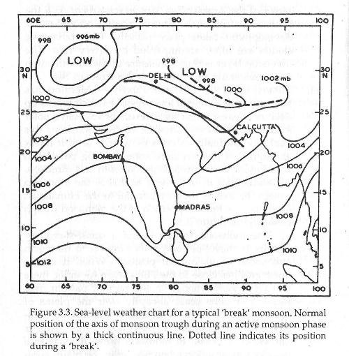
Another feature of a ‘break’ is the westward passage of low-pressure systems across the Indian peninsula. Parts of the peninsula, which lie in the rain shadow of the Western Ghats, derive much of their monsoon rainfall during ‘break’ situations. On the other hand, when the axis of the monsoon trough moves south and tends to dip into the Bay of Bengal, conditions become favourable for the formation of a low or depression. The westward passage of a depression is accompanied by heavy rain. Consequently, a southward position of the monsoon trough is usually an indication of well-distributed rain over central India and the Indo-Gangetic plains. According to studies the formation of monsoon troughs is closely related to the radiation balance of the earth-atmosphere system during the monsoon.
Intense rainfall is often generated by low-pressure systems, which appear to be embedded within the monsoon trough. These systems are seen as zones of falling pressure with counter-clockwise winds around them. They do not have the intensity or dimension of a proper depression, yet the rainfall generated by these shallow systems is high. These short period fluctuations of monsoon rainfall reflect spells of heavy rain with duration of three to seven days.
Of the other macro-scale variation of rainfall, it is observed that monsoon circulation features attain their maximum northward extension into India around the beginning of August. It is also observed that around mid-August we usually have the maximum frequency of ‘breaks’ in monsoon rainfall. In fact, there appears to be considerable difference in the rainfall patterns of July and August. This points to the fact that there are wide day-to-day regional variations of monsoon rainfall. The monsoon cannot be regarded as one uninterrupted rain for the whole country.
The monsoonal flow in the lower atmosphere below 6.0 km undergoes pronounced changes during active and ‘break’ phases of the monsoon. How far these changes are influenced by events that take place far to the east or to the west of the monsoon regime is still a matter of conjecture. There is considerable evidence to suggest that the atmosphere could support a large number of waves on different scales. Some evidence has been produced to suggest two main periods of oscillations in monsoon rainfall: one is of five days duration and another is with a period of 15 days. They suggest a rhythmic fluctuation in the intensity of rainfall with a period of 5 or 15 days. Some have also found evidence of a 30-40 day oscillation in the tropics. It has been suggested that waves of this nature are created by the internal dynamics of the tropical atmosphere. One can experience this type of oscillation in the intensity of rainfall at Cherrapunjee